Hammondsport is located at the south end of Keuka Lake. Known best for wineries and microbreweries today, it was one of the very worst affected areas from the devastating 1935 flood.
Corning Landing, so named for the number of Corning residents with summer cottages there, sits on Keuka Lake near the village of Hammondsport in Steuben County.
Keuka Lake is part of the Oswego River Basin, an area of over 5,000 square miles that drains into Lake Ontario. Keuka Lake water levels are regulated by the village of Penn Yan in Yates County, on the north end of the lake. Excess water from Keuka Lake is sent to Seneca Lake, which in turn can send excess water to Cayuga Lake. Seneca Lake water levels are regulated by the State of New York using the Waterloo Dam and Tainter Gates of the Cayuga-Seneca Canal first built in 1913. These controls, while in place in 1972, could not reduce flood levels fast enough for the rate of rainfall caused by Agnes.
Hammondsport had an additional concern because of Glen Brook, which comes from the northwest and travels south through the village before flowing into Keuka Lake.
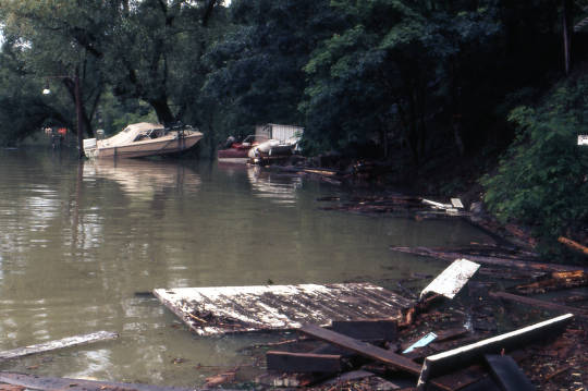
Boats in Corning Landing on Keuka Lake. Courtesy of the Steuben County Historical Society.
Houses in Corning Landing along Keuka lake were damaged, and watercraft were displaced as the lake’s water level rose and fell three feet in just two days.

Partially submerged boathouse in Corning Landing on Keuka Lake. Courtesy of the Steuben County Historical Society.
Local residents Robert and Elizabeth Turissini spent the night of the flood securing drifting boats to whatever they could find, and later donated the photographs of their experiences.

Location of major lakes and rivers, New York State Barge Canal, and major cities within the Oswego River basin in Central New York. Courtesy of the U.S. Geological Survey.
As Hurricane Agnes dropped between 6 and 10 inches of water on the Finger Lakes region, flood control efforts throughout the Oswego River Basin struggled to keep up. Coincidentally, Lake Ontario and other Great Lakes already had higher than usual water levels in June of 1972.

Reservoir Hill Road in Hammondsport. Courtesy of the Steuben County Historical Society.
In this photograph near Reservoir Hill Road in Hammondsport shared by the Steuben County Historical Society on Facebook, the flood control efforts done after the 1935 flood prove their worth. This area pictured was built up to contain and divert overflows from the Glen Brook, as that waterway had caused the severe flooding in 1935. Water levels are typically ten or more feet lower than seen here.
Without these improvements, notes Steuben County Historian Kirk House, the 1972 flood would have been significantly worse for Hammondsport.