Background on the Holland Land Company in Western New York Before the arrival of the first settlers, the area of western New York State, known as "Genesee Country," was the home of the Seneca Indians. Robert Morris of Massachusetts purchased Genesee Country in 1791 and sold it to the Holland Company, a group of Dutch bankers, on July 20, 1793. The Holland Company opened for business in 1800; the first land sale was in 1801; and the company moved the office to Batavia when Genesee County was founded in 1802. The beginnings of the Holland Land Company date back to 1789, when four Amsterdam firms, P. Stadnitski, N & J van Staphorst & Hubbard, P & C van Eaghen & Ten Cate, and Vollenhoven together sent an agent to the United States to keep them informed of financial developments and to invest money in the new country. Van Staphorst and Willink were two Dutch firms that had made loans to the United States government during the American Revolutionary War. The "Club of Four," as it was called, invested in different funds such as the South Carolina Funded Debt, the Massachusetts Deposit, and the Pennsylvania Population Company. The group also invested in canal construction companies in 1791 and 1792.
The agent sent to keep the Dutch investors informed was Theophile Cazenove. Cazenove arrived in the United States in 1790 and settled in Philadelphia where he entertained and met with many influential people in American business and politics. In August 1791 Cazenove advised the Club of Four to begin buying land in the wilds of America. The van Staphorst firm was reluctant at first but joined in the venture after the other three firms began to buy land. The Dutch banking firms of W. Willink and RJ Schimmelpennick began to cooperate with the other four banking houses in September 1792, creating the "Club of Six." Three months later, Cazenove bought 1.5 million acres in tracts 4 and 5 of the Genesee Lands from Robert Morris, Sr. At the same time, the Club of Six bought another 1 million acres in tract 2 from Robert Morris, Jr., and obtained an option for another 800,000 acres, which they later bought. They also purchased 700,000 acres east of the Allegheny River in Pennsylvania and about 77,000 acres in Central New York. Some of the firms wanted to sell the lands quickly to speculators while others preferred to wait for a better opportunity.
In order to create a market, the firms decided to merge their holdings into one stock company, and on November 20, 1795, the Holland Land Company was formed. Before the survey could begin, financier Robert Morris had to clear the land title from the Seneca Indians. In late August 1797, representatives from the American government and Robert Morris arrived at Big Tree, just outside the present Village of Geneseo in Livingston County. The negotiations began on August 28, 1797. Joseph Ellicott, a respected surveyor, was invited because he knew the territory from his travels through the area to Upper Canada eight years earlier, and he had a friendship with several Indian chiefs. There were three parties involved in the negotiations: Robert Morris, the Seneca Indians, and the United States government. Representing Morris was his son, Thomas. Over 1,000 Senecas were present, led by Red Jacket, Farmer’s Brother, and Cornplanter. Jeremiah Wadsworth represented the federal government. The Holland Land Company sent a team of six men as observers. Their orders from Philadelphia were to stand on the sidelines and not be publicly involved. Paolo Busti, the new General Agent for the Holland Land Company (replacing Cazenove in 1796) was also present. Discussions seemed to stall and at one point, Red Jacket, Farmer’s Brother, and Cornplanter refused to sign the treaty. Morris then tried a new tactic. He promised Seneca women 60 cows and gave annuities to some of the chiefs. Red Jacket received $600; Cornplanter received $300; Farmer’s Brother and Billy received $100 each; and Little Beard received $50. The Treaty at Big Tree ended a little more than two weeks after it began. The Senecas retained a little less than 200,000 acres and received $100,000 of the Bank of the United States stock with the dividends paid semi-annually. With the signing of the Treaty of Big Tree, Morris transferred the title to 3.3 million acres of land in western New York to the Holland Land Company.
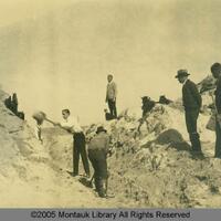
Theophilus Cazenove, the Agent-General of the Holland Land Company, hired Joseph Ellicott as Chief Surveyor in July 1797. Ellicott's experience included surveying the company's land in northwestern Pennsylvania. After extinguishing the Seneca Indians' claim to the land at Big Tree, Ellicott's objectives for the survey were to lay out the 3.3 million acres of company land, arrange the specific boundaries for the Seneca Indian Reservations and subdivide all the towns into six square miles. The surveyors were also required to complete field books describing the land, waters, mill seats, valleys, mines, minerals, and any other information that could be useful for the Company when selling the land. One of the first obstacles Ellicott faced was his concern for accuracy as the United States lacked a standard of measurement. Ellicott solved this by collecting a number of rulers, determining the average, and designating that as the figure for a one-foot length. Ellicott became the first person to use the one-foot ruler that we use today. The second obstacle was the need for a portable transit instrument. Andrew Ellicott, Joseph's older brother, was using the only one in the country in Florida where he was surveying the boundary between the United States and Spanish lands. The instrument was used to observe the transits of heavenly bodies, essential for working in the deep woods where a compass would not be as accurate. Joseph had his mechanically inclined younger brother, Benjamin, build a new transit instrument for use in western New York. The survey that started in March 1798 ended October 1800 and cost the Holland Land Company over $70,000. Today, this transit can be seen on display at the Holland Land Office Museum in Batavia, NY. Principal surveyors in the first season included: Joseph Ellicott (Chief Surveyor), Benjamin Ellicott, John Thompson, Richard M. Stoddard, George Burgess, James Dewey, David Ellicott, Aaron Oakford, Jr., Augustus Porter, Seth Pease, James Smeadly, William Shepard,, and George Eggleston. Ellicott’s carefully organized report included notes from the field describing the quality of the land, including types of trees (sugar maple, beech, oak, ash, and elm trees were abundant), potential sites of towns and suitability of the soil for raising corn, wheat, rye, and other grains. The report also identified different types of wildlife within the terrain, including rattlesnakes, bears, wolves, elk, foxes, deer, minks, otters, and other animals.
With the Great Survey finished, the next step in settling the vast tract of land was to find an agent with the planning and organizational skills to turn the wilderness into a new frontier. The Holland Land Company considered several candidates before appointing Joseph Ellicott, who remained in his position until 1821 (the last agent for the Company was appointed in 1837). Paolo Busti, Agent-General of the Holland Land Company, and Joseph Ellicott signed the contract on November 1, 1800, in Philadelphia. For the next 20 years, Ellicott held the post of Resident-Agent in charge of land sales on the Holland Purchase. In order to expedite the sales of land in this vast parcel, several subagents were appointed in various areas. In the southern tier, subagents included William Seward (future Secretary of State under Abraham Lincoln) and N. Deveraux; in Buffalo there was subagent L.A. Blossom; and in the Niagara Orleans Genesee area, LeRoy en Redfield Ellicott set up the first land office in the tavern of Asa Ransom in Clarence Hollow in 1801. A year later, he moved it permanently to Batavia.
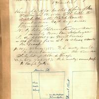
Through Ellicott's influence, the Holland Land Company implemented programs to encourage settlement by giving loans to settlers to build mills on the Purchase. The Company also gave land to the first two blacksmiths in the area. The Company loaned $3,000 to assist the establishment of the first general store in Batavia and offered free land to anyone who would open inns at 10-mile intervals along the newly opened roads. The Company also donated money and land to establish churches and schools. The Holland Land Company sold land to individual settlers by an Article of Agreement, and the settlers received the deed upon full payment. The plan started to change in 1802, when Genesee County was formed. New York State law required county officers and voters to be landowners, and Ellicott estimated there were fewer than 30 landowners in the entire county, making it almost impossible to gather enough people for the positions available or to summon a jury. Ellicott changed the policy by giving a settler the deed when 25% of the purchase price was paid. Ellicott and Busti differed on the payment policies. Ellicott thought the way to populate the Purchase was with liberal credit terms that would give the settlers 10 to 12 years to pay. He believed that selling land to poor, landless families would encourage them to work hard clearing and developing the land. In Ellicott's view, western New York would cease to be the frontier, and land values throughout the Purchase would increase. The Erie Canal also helped move people into the lands owned by the Holland Land Company. Although he personally doubted the canal project would ever be completed, Ellicott publicly praised the idea of the Erie Canal because it would greatly increase the value of land, at little expense to the company. He estimated it would raise land values near the canal from $3 per acre to over $20. He also thought the canal would allow settlers to transport goods to market at less than half the current cost. Busti and Ellicott discussed the terms of an offer to the State of New York and finally the Holland Land Company donated 100,632 acres of land in the southern part of the purchase. The conditions for the donation stipulated that the state would pay tax on the land and return it to the Company if the canal was not built within 15 years. On November 27, 1813, the Canal Commission accepted the offer, and the project was one step closer to becoming a reality. The Erie Canal was finally completed in 1825 (from: The Great Survey, 1798-1800 and The Life and Times of Joseph Ellicott, both by Patrick Weissend).
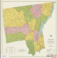
The original county encompassing the area of the Holland Purchase was Genesee, named for the Seneca word meaning "beautiful valley." Genesee County was initially divided into only four "Shires" or towns: Batavia, Northampton, Southampton, and Leicester. Gradually, parcels of land were taken from Genesee County to form other counties: Allegany (1806), Cattaraugus (1808), Chautauqua (1808), Niagara (1808), part of Livingston (1821), part of Monroe (1821), Erie (1821), Orleans (1824), and Wyoming (1841). What was left is the present Genesee County (from: Genesee County History, by Betty Thomas). Related Resources Below are several sites that have additional background information, as well as lesson plans for teachers relating generally to land surveying in American History and specifically to the Holland Land Purchase and Survey in western New York:
Joseph Ellicott (1760-1826) Andrew Ellicott (1754-1820) The Holland Land Purchase Joseph Ellicott (1760-1826)The Holland Land Purchase and Holland Land Company RecordsThe Holland Land Company and Joseph EllicottTraces of the Holland Land Company Survey of New York StateHow Simeon DeWitt Mapped New York State (NY Map Society article)19th century Monographs on the History of Western New YorkEarly American Surveyors: Mapping the Wilderness (Professional Surveyor Magazine)Virtual Museum of SurveyingThe Public Land Survey SystemHistoric USGS Maps of New YorkLand Ordinance of 1785 (excerpts)Teacher Guide — For Land's Sake: George Washington as Land Surveyor Lewis & Clark: Discovering, Mapping the West Mapping on the TrailAndrew Ellicott (1754-1820)The Lewis and Clark Expedition and the USGS (lesson plan)