New York State Rural Farm Registers

Cover Image:
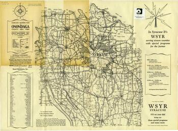
Compass System Map of Onondaga County
Compass System Map of Onondaga County - Image Source

Collection Facts

Extent:
2
Dates of Original:
1936-1937

Historical Context

The 1936-37 Special Classified Farm Register of All Farms in Onondaga County rural directory locates farms and agricultural property in Onondaga County.  The Compass System Map of Onondaga County for 1938 shows locations of farms and other agricultural properties in Onondaga County.  The map uses a "compass system," which identifies properties using concentric circles corresponding to the distance from population centers.  Property owners are listed by last name in the accompanying directory. 

Scope of Collection

This collection consists of a 1936-37 Special Classified Farm Register of All Farms in Onondaga County and a 1938 Compass System Map of Onondaga County.