Collections
![Map of the Western part of Township No. 12 - 7th Range](/sites/default/files/styles/browse_thumbnail/public/content/collection/covers/YGM0080040.png?itok=7i-thlYj)
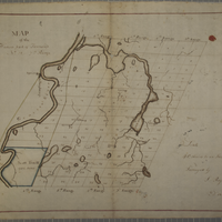
The maps (and, for some, associated documents) in this digital collection represent a portion of the 300+ in the physical Wadsworth collection and cover areas within townships, tracts, and counties in the Genesee Valley region.
![New Atlas of the City of Plattsburgh, N.Y. 1916](/sites/default/files/styles/browse_thumbnail/public/content/collection/covers/Screen%2520Shot%25202018-10-09%2520at%252011.38.39%2520AM.png?itok=FgVuJV1Q)
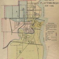
This collection contains the New Atlas of the City of Plattsburgh from 1916.