Tompkins County Flood Photographs

Cover Image:
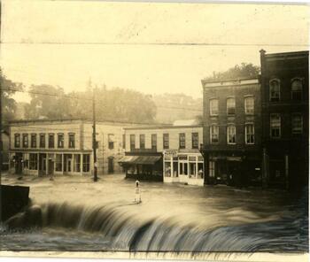
Intersection Rt 96 (Main St.) and Union St in Trumansburg covered in flood water
Intersection Rt 96 (Main St.) and Union St in Trumansburg covered in flood water - Image Source

Collection Facts

Extent:
35
Dates of Original:
1935-1956

Historical Context

Tompkins County has suffered several major floods throughout its history. Situated in New York’s Finger Lakes region, its many creeks and streams, as well as Cayuga Lake itself, pose considerable threats during and after heavy rainfalls. In 1857, 1901, 1935, 1956, 1972, and 1981, the area was devastated by floods that destroyed property and threatened (and took) lives and livelihoods. In 1935 the small village of Trumansburg alone suffered five deaths and more than $700,000 in damages, a horrific toll that required state and federal relief assistance and took months to recover from.

Scope of Collection

These black and white images are from The History Center’s General Photo Collection, the largest and most diverse of our many photograph collections. Most are the work of unknown photographers, and they date from ca. 1901- ca. 1956. Most document the ravages of the 1935 flood, but some cover the floods of 1901 and 1956 as well

Special Content:

This collection was supported in part with federal American Rescue Plan Act (ARPA) funds allocated to the New York State Library by the Institute of Museum and Library Services (IMLS).


Browse within this collection

By Subject:

Browse similar collections

NYH Topic Areas:
Collection Type: